


EO/IR/LD orSurveillance Radar
100 hp InternalCombustion Engine
150 kgPayload
Bayraktar TB2
Armed Unmanned Aerial Vehicle
A combat-proven medium-altitude, long-endurance platform.
Fully autonomoustaxi, take-off, cruise and landing.
Effective and reliable mission execution across diverse operational conditions.
General Information
Medium altitude,long endurance.
Developed for intelligence, surveillance and reconnaissance missions, TB2 delivers high mission safety through its triple-redundant autopilot and advanced sensor fusion.
Flight Hours
0+
hours in the sky
A platform that has proven itself on the battlefield.
Key Flight Performance
- 16,000 Feet
- Operational Altitude
- 27 Hours 3 Minutes
- Flight Record
Different geographies,the same reliability.
Across numerous theatres of operation, from Karabakh to Libya, from Syria to Ukraine.
Independent of ground systems,fully automatic landing.
Precise automatic take-off and landing supported by internal sensor fusion.
Bayraktar TB2
“The world’s most actively deployed UAV.”
GeneralInformation
The Bayraktar TB2 Armed Unmanned Aerial Vehicle (UAV) is a combat-proven Medium Altitude Long Endurance (MALE) platform. Developed for intelligence, reconnaissance, and surveillance missions, the TB2 ensures high mission safety and operational continuity through its triple redundant autopilot system and advanced sensor fusion architecture. With fully autonomous taxi, takeoff, cruise, and landing capabilities, it performs effectively and reliably under diverse operational conditions.
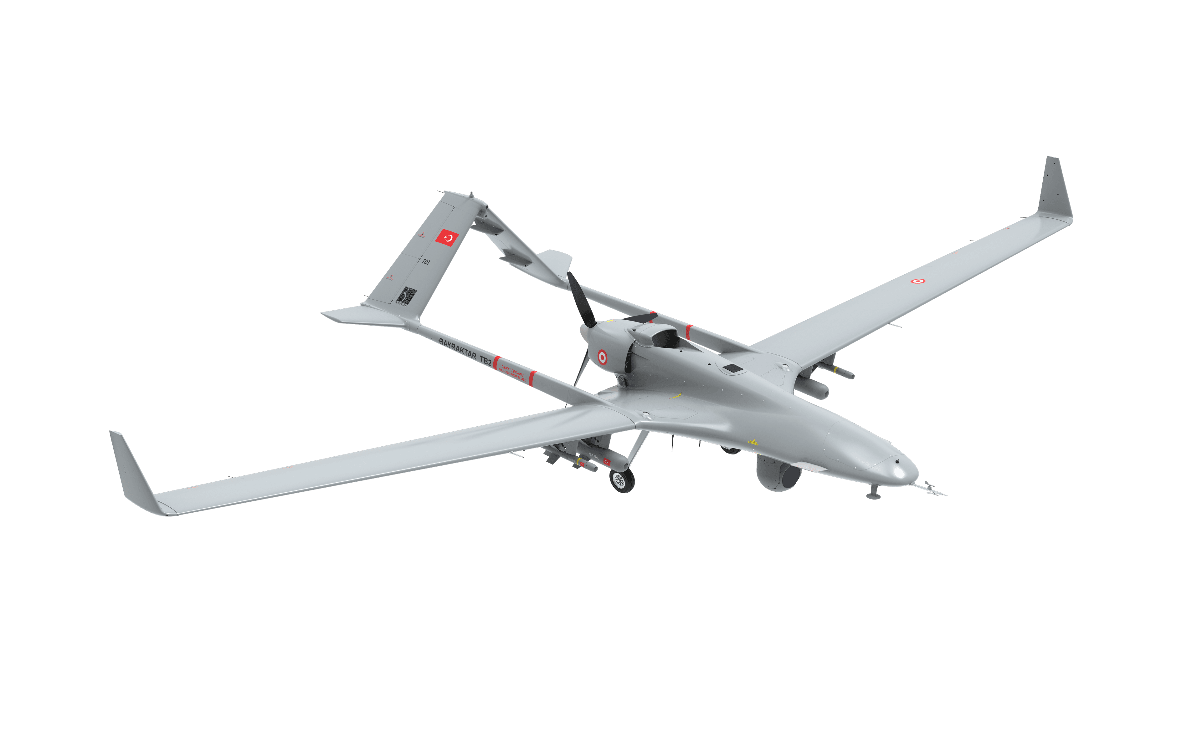
Over 1 Million 250 Thousand Hours of Operational Flight
In addition, the Bayraktar TB2 is configured for precision strike operations, featuring proven smart munition integrations that support accurate target acquisition and precise engagement. Demonstrating its effectiveness and operational reliability across multiple theaters of operation—from Karabakh to Libya, and from Syria to Ukraine—the Bayraktar TB2 has successfully operated in diverse geographical, climatic, and threat environments, proving itself on the battlefield.
“The world’s most actively deployed UAV.”
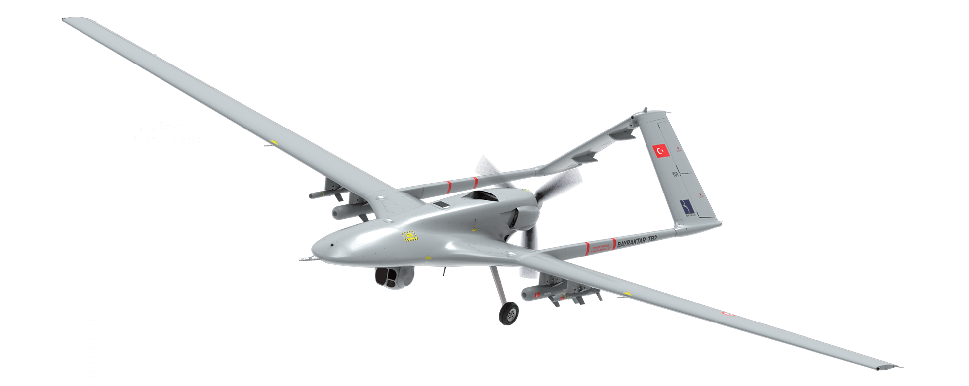
Basic flight performance criteria
- 16,000 Feet Operational Altitude
- 27 Hours 3 Mins Flight Record
- Fully Automatic Flight Control and 3 Redundant Autopilot System (Triple Redundant)
- Fully Automatic Landing and Take-off Feature Without Dependence on Ground Systems
- Navigation with Internal Sensor Fusion Without Dependency on GPS
Advanced Features
- Fully Automatic Navigation and Route Tracking Feature
- Precise Auto Takeoff and Landing with Built-in Sensor Fusion
- Fully Automatic Taxi and Parking Feature
- Semi-Autonomous Flight Modes Support
- Fault Tolerant and 3 Redundant Sensor Fusion Application
- Cross Redundant YKI System
- Unique Redundant Servo Actuator Units
- Unique Redundant Lithium-Based Battery Units
TechnicalSpecifications
- Service Ceiling
- 20.000 feet
- Operational Altitude
- 16.000 feet
- Communication
- LOS & BLOS
- Travel - Maximum Speed
- 90 KTAS - 110 KTAS
- Endurance
- 18+ hours
- MTOW
- 700 kg
- Payload Capacity
- 150 kg
- Take Off/Landing/Cruise/Taxi
- Autonomous
- Power Plant
- 100 hp Internal Combustion Engine
- Versions
- TB2-A, TB2-B, TB2-C and TB2-D
- Payload - ISR
- Simultane EO/IR/LD or Surveillance Radar
- Payload - Munitions
- Laser Guided Munitions, INS/GPS Guided Munitions, IR Guided Munitions, Mini Cruise Missiles
- Wingspan
- 12 m
- Length
- 6.4 m
- Height
- 2.2 m
Real-Time Imagery Transmissionand Back-Up System
Baykar Real Time Imagery Transmission System (BGAM) provides real-time image transmission and processing solutions to the defense industry. BGAM allows high-resolution, non-delay live broadcasts to be monitored by multiple users at the same time. BGAM is a web-based application that allows users to watch live broadcasts securely on the network or on tablets using the mobile application via internet.
The system automatically stores all transmitted imagery into 30-minute files. While monitoring live imagery, users can take multi-tag notes on the system. Saved tags and labels will facilitate, at a later date, the search through archive videos. In a similar way, based on these notes, a mission log can be created and then exported. Archived files can be filtered by date and by metadata.
For security reasons, the system automatically regenerates temporary passwords to secure access to live transmitted and archived imagery. The user name or device information watermark appears on all live and archived video files.
Optionally, an embedded software can be integrated to the Imagery Transmission System allowing live transmission to mobile devices operating Windows. The data transfer from highly secured network to mobile devices is secured by Adopting end-to-end encryption method (also called data diode model).
Ground ControlStation
TB2 uses triple bands for LOS control and video transmission.
Baykar Mobile Ground Control Station (Mobile GCS) ensures the remote control of the Bayraktar TB2 platform from the forward bases, far from the central command centers. The powerful communication antennas of the Mobile GCS expand the mission range by allowing Bayraktar TB2 UAVs to take off and land to/from their current locations.
Consistent with NATO ACE III shelter standards, the mobile GCS encompasses a hydraulic driven aerial platform that can be raised up to 12m, automatic oriented antenna systems and a powerful truck providing mobility to all these components with hydraulic outriggers. The Mobile GCS is Baykar’s own design. It is equipped with cutting-edge sensors and control valves allowing it to be set up safely in a short period of time.
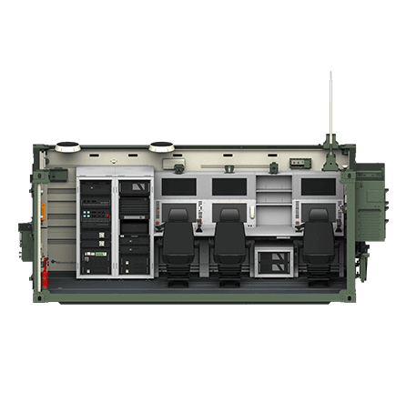
Ground Control Station
- Radio Systems
- Internal Conversation Systems
- Adjustable Tower Working Speed
- Pilot Console
- Payload Operator Console
- Image Exploitation Console
- Rack Type Cabinets
- Power Systems, Filters
- Power Supply Units
- Military Type Two Air Conditioning Units
- NBC Filtration System
- NATO Spec ACE-III Shelter Features
Bayraktar TB2
You can view 360°